Mapping your fields boundaries in MRV
Drawing the Line Right: Ensuring Accurates Boundaries in MRV Systems
Introduction
One of the key aspects of an effective MRV is defining clear and accurate field boundaries. Poorly defined boundaries can lead to inaccurate data, compliance risks, and inefficiencies.
This article provides guidance on common issues and best practices for defining accurate mapping.
Key Risks of Inaccurate Field Boundaries
-
Remote sensing tools and pre-filled data (OpTis) may fail: Inaccurate or misaligned boundaries can lead to incorrect satellite-derived information, reducing the reliability of pre-fill and automated practices verification processes.
-
Data quality and reporting issues: Inaccurate boundaries may cause land misclassification, double-counting, or gaps in reporting, leading to errors and back-and-forth in MRV audits.
-
Loss of compliance and stakeholder trust: Poor-quality boundary data can result in non-compliance with MRV protocols and damage the credibility of reports with verifiers and other stakeholders.
Common Boundary Issues in MRV Systems
1. Overlapping Fields
Avoid scenarios where two or more fields share overlapping boundary areas, as this leads to double-counting in area calculations and inconsistencies in reporting.
Regrow MRV systematically ⚡ identifies overlapping field boundaries submitted by the same producer or those that intersect with boundaries submitted by other growers, and it will generate an error during the enrollment process. The Regrow team is available to provide support in identifying any areas of overlap that may not be immediately apparent. The threshold for allowable overlap can be configured in the program settings, enabling flexibility based on project requirements.

2. Overlap with Non-Agricultural Land
Ensure that defined boundaries do not extend into areas that are not relevant to the MRV system, such as urban zones, forests, or water bodies.
Regrow MRV can automatically ⚡️ flag overlap with Non-Agricultural Land (roads, waterways, and non-cultivated areas) in some geographies:
- Physical boundaries (roads, rails, water) checks are coming from OSM (Open Street Map),
- Ag Land checks come from the following sources: National Landcover Dataset;, PFT, a plant functional type dataset for grazing lands produced by the university of Montana, and the Cropland Data Layer (US specific).

3. Fields Too Small
Generally, fields below 1ac can be associated with neighbouring fields, unless they have distinct management practices.
Remote sensing is less reliable when used on small fields.

4. Multipolygons with Polygons Too Far Apart
When polygons within a multipolygon are located far apart, it's often a sign they represent areas with different land management practices. Grouping these distant parcels into a single field can compromise MRV accuracy, as assumptions about consistent land use, cover, or emissions may not hold.
In the example below, a small parcel is situated several kilometers from the main field. It likely belongs to a separate field and should be mapped accordingly.

5. Field Outlines (Empty Inside)
Verify that the boundary encloses valid data and does not represent hollow or missing data. In the example below, only the field edges will be quantified and audited, while the entire field could have been mapped.

6. Abnormal Shapes
Watch for irregular geometries that don't align with typical agricultural field shapes, such as narrow strips resembling roads, drains, or riverbeds.
These features can be mistakenly included in mapped field boundaries but should be excluded from MRV enrollment.

7. Duplicated Field Boundaries
The system will identify duplicate fields as boundary overlaps. To assist in detecting these occurrences, consider the following guidelines:
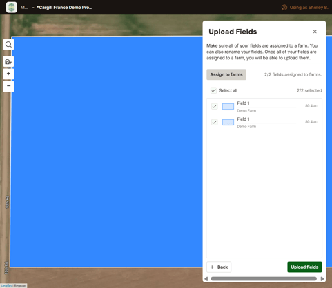
- Upon uploading the fields to the platform, you may observe instances of duplicated field names, provided they are identical, along with corresponding field shapes and sizes that match. This situation may occur when a field boundary has been manually drawn or selected, followed by the addition of a file boundary.

Please be advised that field boundary files containing duplicate boundaries will be rejected during the upload process to prevent issues related to double boundaries.
- In the example below, the duplicated field is highlighted using a different shade of blue for clarity. Upon reviewing the field list on the right, it is evident that Field A and Field B exhibit a close resemblance; however, there is a slight discrepancy in their sizes. By selecting the field on the map, users can observe the overlapping nature of these two boundaries. The appropriate course of action is to remove one of the duplicates, retaining the most accurate boundary for clarity and compliance.

Should you experience any difficulties, do not hesitate to contact our team via email at support@regrow.ag, and we will provide the necessary assistance.