Overview
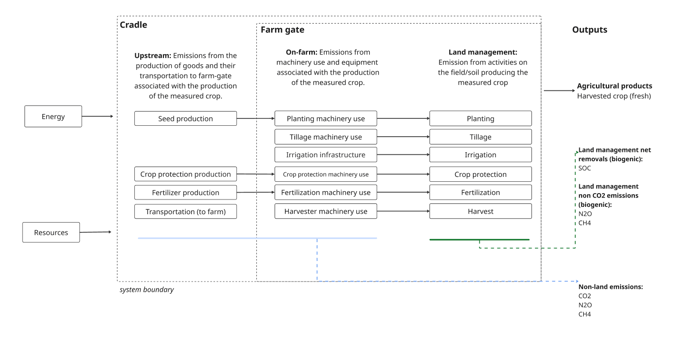
This inventory methodology quantifies cradle-to-farmgate emission factors associated with the production of a measured crop on agricultural land. Emissions quantified include CO2, CH4, and N2O (with CO2e conversions) that are within the system boundary.
More specifically:
-
Land management (biogenic) (Tier 3): are exclusively modeled via DNDC today.
-
Non-land (upstream and on-farm emissions) (Tier 1): are informed by the on-field management activities in order to quantify the following:
-
Irrigation infrastructure
-
Crop protection production
-
Seed production
-
Fertilizer production
-
Machinery use (from tractor activity)
-
Transportation (from production to farm gate)
-
All emissions are then provided in a single inventory outcome for the field and/or project.
Calculations are only available today in regions with DNDC and Monitor API coverage.
Crop coverage
Calculations are only available with crops in the supported crops page.
Outcomes
Outcomes are reported at the field level. Outcomes are broken into each up-stream and on-farm activity as informed by the crop production activities on the field.
Emissions reported are dSOC (biogenic on-field), CO2 (non-biogenic), N2O (direct and indirect on-field and up-stream) and CH4 (on-field and up-stream). Individual gases will additionally be converted to CO2e with units kg CO2e per kg yield (the emissions multiplied by the GWP values. See GWP methodology for more information).
The user may optionally choose to convert their output to a per area emissions.
Calculations
Regrow’s upstream and on-farm emission factor calculations, in their simplest form are:
Field activities x emissions for that activity = emissions / yield
Measured crop functional units: Quantification of emissions is per measured crop. The functional unit/output of the system is the production of 1 kg of fresh crop harvested.
Allocation: 100% emission created are attributed to the measured crop. There is no support for co-products.
Units reported: kg of gas (or CO2e) / kg of yield
-
If there is a 0 kg CO2e/kg yield, then that means there are 0 or limited emissions produced from that activity.
-
If there is a null value, then that means there is insufficient data at this time to generate an emissions factor. Please contact Regrow.
LCIA method: GWP, IPCC AR6 100-year
Data sources
Field boundary: Emission factors are generated at the field level; likewise, the field boundary is the foundation of Regrow’s calculations. The field is the area that is used in the production of your measured crop. This should be a single field or single managed unit.
The location is used to inform both the emissions factors as well as any defaulted management data used. When mapping the field to a geographic region, we use the ‘best-available’ which is the lowest level geographic coverage that we have available for that activity.
-
For example, if the field is located in Kansas, then emissions for tillage machinery use would be taken from the “US” country geographic coverage area.
Equations: All equations are global. There is not a country or sub-country specific equation (see Tier methodology for definitions).
Emissions coefficient data source: EcoInvent v3.11 “cut-off” was used for all emissions datasets. The "cut-off point" is the end of the waste treatment activity, at which point the resulting product (such as waste water) enters a new product system as a burden-free input.
Regrow uses Ecoinvent’s data sets and aligns them to match on-field activities. Likewise, each activity calculation has it’s own methodology summarizing the approach and assumptions we took.
The field’s boundary informs the geography in which the Ecoinvent emissions coefficient is used.
Management data (defaulted and user-provided): When a user provides on-field management data directly, then those are always used. However, in some cases, users cannot or choose not to provide detailed primary data for all on-field data required to generate an emission factor. So Regrow has created a library of on-field management data sourced from various literature, science resources, and industry publications, which will be used in the case that no data is provided by the user. Those citations are listed within each activity methodology.
Limitations
Some crops in some regions for some activities do not have sufficient data to generate an emission factor. This can be either: No default management data available or No emissions data available. In those cases the results will be displayed as: null.
-
In the case that values are aggregated up to a field or project level, nulls will equate to 0 in the aggregation but will always be null in the activity itself. For example:
-
Field A total:
n20_emissions_factor_kg_per_kg_yield: 23.0 (with N2O from fertilizer production = 0 in this aggregation)-
Field A fertilizer production activity:
n20_emissions_factor_kg_per_kg_yield: null (this is where you would identify fertilizer production as null)
-
In some regions and activities there is limited emissions data for a specific crop. In those cases, the crop has been mapped to the closest available.
Uncertainty and sensitivity are assumed only from Ecoinvent’s data. There is no additional uncertainty applied to the final upstream emissions factors generated.